Saturday, August 10, 2013

Copyright Infringed?

What a Difference a Decade Can Make!

These two post cards look extremely similar.
The titles are even almost the same title. If you look at the clouds in the background they are the same shape. There is a dead tree on the right-hand side of both post cards, too. Even the oranges are growing in the same spots on the trees. I have to admit that I much prefer the top card to the bottom one.

This is a good illustration of how either a) the post card publishers ignored the copyright rules, or b) how one company who owned the copyright sold the same picture to two different publishers. Both of these were common in the early days of post card publishing and selling.

In order to find the answer to this “question” one must turn the post cards over.
When you do, you can see that the top post card was mailed on May 6, 1911 (the clear postmark) and the bottom one was mailed around March 11, 1923 (the hand written date and only the year on the postmark).

The top card was published by the Newman Post Card Co. in Los Angeles and San Francisco, California. Founded in 1907, they were a publisher and printer of lithographic postcards, mostly views of southern California, with some cards of Hawaii and Nevada and the 1915 Panama Pacific Exposition. They were related to the O. Newman Company. In the 1960s they were purchased by H.S Crocker and so they kind of still exist. It was printed by the Van Ornum Colorprint Company out of Los Angeles. This company was in existence from 1908 to 1921. Knowing the dates of these two companies, we can date this card to between 1907 and 1921. We can, of course, date it even closer because the postmark says May 6, 1911.

The bottom card was published by the M. Kashower Co. of Los Angeles. They existed from 1914 to 1934. These publishers used a variety of printers to produce their comic cards, holiday greetings, and view-cards of southern California. This card, too, was printed by the Van Ornum Colorprint Company. We could do the math to figure out between which years the post card could have been printed, but the postmark tells us it was mailed in 1923.

My conclusion to the question above is that the Van Ornum Company owned the print and sold it first to the Newman Post Card Company then to the M. Kashower Company. Maybe they got around any copyright agreements by changing the title on the front from “Entering Southern California” to simply “Entering California”.

Friday, August 2, 2013

Way Up North - part two

Here is part two of the previous post. This is the post card in my collection that looks just like the picture on the White Pass and Yukon Railroad's website.
This is not a very good scan of the post card. It is a picture of, as is written on the front of the card, "Steel Cantilever Bridge over Dead Horse Gulch". I know that it is on the White Pass and Yukon Railway because the message on the back says, "You'll be glad to hear that we missed the ride on this train - Yukon and White Pass R.R." This confirms for me that the post card in Way Up North - Part One is of this bridge on this railroad.

The post card was printed by Gowan Sutton. They were a publisher of real photo and printed postcards of the Canadian West. Not only did they produce cards depicting large cities, they captured many hard to reach views within the Canadian Territories. Many of their cards were hand tinted in a simple manner striving for style rather than realism, which created cards in vastly differing quality. While the real photo cards were made in Canada their printed cards were made in England. They were in business from 1921 to 1960 in Vancouver.

Way Up North - part one

The front of this post card is titled: "SERVICE OF THE NORTHLAND, ALTIN, B.C." While searching for "Altin" I found nothing, but another town showed up: Atlin, British Columbia. I followed my instincts and found that the name of the post card is misspelled.
Atlin is an existing small isolated community in the NW corner of British Columbia, on the traditional lands of the Taku River Tlingits. Glacial-fed Atlin Lake is 4 miles wide and 85 miles long, in a wide wilderness valley surrounded by snowcapped mountains. Atlin is a 2 to 3 hour drive from Whitehorse Yukon or Skagway Alaska. Current population is 300 to 500 full-time residents. During the Klondyke Gold Rush of 1898, the population was 10,000! Many buildings from that era still exist. Though Mining and Tourism underpin the economy of Atlin, there is a large and very influential number of artists, artisans and authors in this very special little-known community. This information was taken from the website of the town: discoveratlin.com If you draw a straight line between Whitehorse in Yukon and Juneau in Alaska, Atlin is at the half-way point and a few kilometers east of the line. Atlin was founded in 1898 after European explorers Fritz Miller and Kenny McLaren discovered gold nearby in Pine Creek. The White Pass and Yukon Railway Company recognized Atlin's potential as a tourist destination and promoted the town to the fullest.

I also found that Atlin had at least three railway companies named after it:

The Atlin Railway Company was incorporated in 1914 and went from Atlin to a point on the US boundary at Taku River.

The Atlin Short Line Railway and Navigation Company was incorporated in 1899 to build from Taku Arm, Cassiar District, along the valley of Atlintoo River, on the north side of the river, to near where the Atlintoo River leaves Atlin Lake. The company was dissolved by the Defunct Railway Companies Act of 1926-27.

The Atlin Southern Railway Company was also incorporated in 1899 to build from Log Cabin, on the White Pass to the Taku Arm of Taglish Lake, from the entrance of Atlintoo River into Taglish Lake and from Atlin City to Telegraph Creek,with branches.The company was also dissolved by the Defunct Railway Companies Act of 1926-27.

In my searching I also found a picture on the White Pass and Yukon Route Railroad's website (wpyr.com). The bridge on that card looks extremely like the bridge on this post card. So I am concluding that this train belonged to the original White Pass and Yukon Railway. My next step was to look at my collection of train post cards and see if I could corroborate the story with some other kind of "proof". I am posting that picture today in a second post because the blogging site's program is having trouble doing what I want it to in this blog posting. So, take a look at Way Up North - part two.

In the upper right hand corner of the back of this post card, where the stamp usually goes, the letters AZO are printed four times to make the square for the stamp placement. In each corner of this square are four other squares. This tells us that this is a Kodak paper called AZO and was used between 1926 and the 1940s.

This paper and development process was suitable for making contact prints, rather than enlargements for which the source of light would be much weaker.

Because of the destiny of the three railways mentioned above, I have a tendency to date this card into the late 1920s.

Take a look at the second half of this post...

Sunday, July 28, 2013

Hybrid in More Ways than One

We have gone back to the Rocky Mountains in British Columbia, Canada.
This is a picture of a passenger train in the Fraser River Valley. One can see the river in the valley on the right hand side of the post card. There isn’t enough detail to be able to say anything about the engine itself. There is only one engine and it looks like it is pulling a baggage car and three passenger cars. It is on quite the steep slope and the rocks on the slope hint that this part of the railroad was dynamited to be able to get the two parts of Canada united by the transcontinental railroad.

This is a hybrid card. The front of the card looks very much like those printed before March 1, 1907. The printer kindly left a bit of room for the sender to put a short message to the right side of the picture before posting the card.

But, when we look at the back, we see that it was actually printed after March 1, 1907. There is space on the left of the card for the message and the right hand side of the card clearly states: “THIS SPACE FOR ADDRESS ONLY.” It is just under the words Post Card at the top. While the card was printed in Canada, the Canadians could not escape the influence of the American postal system.

Middlesex county Woburn was incorporated in 1642. It can be found near Boston in Middlesex County almost on the eastern coast of Massachusetts. It is near Horn Pond, which is one of the sources of the Mystic River. That is where this card was posted, and yet it has a Canadian 2 cent stamp on it. That makes it again a hybrid: Canadian card and stamp mailed in the USA. Amelia sent this message to her friend, Celina: “Hello Celina, Am enjoying myself very much. This is some country. Love, Amelia.” Celina lived in Montague City, Massachusetts. It is found in the northwest part of the state in Franklin County. It is a very young town, being incorporated in 1754.

The post card was published and printed by Warwick Bro’s. & Rutter, Limited out of Toronto, Ontario in Canada. The firm of Warwick Bros & Rutter published over 7,024 picture postcards during what is now called “The Golden Age of Postcards” (1901-1913).

For some years, the firm made a specialty of the production of picture post cards. It was the first Canadian firm to enter the field with “Made in Canada” coloured cards, leading the way in three color and four color printing processes and making available the highest class of color printing at a popular price.

Source: “Warwick Bros & Rutter Limited. The Story of a Business 1848-1923"

Saturday, July 20, 2013

Huff and Puff and Puff !

Some of my earlier blog postings discussed the various issues that the Canadian Pacific Railway (CPR) had to face as it was building the Transcontinental Railroad. The area near Field, British Columbia was particularly nasty! This post card helps to illustrate just how bad it was.
There are three steam engines pushing what looks like six passenger cars up the hill toward the summit of the Rocky Mountains just east of Field, British Columbia. If you look carefully, in the lower right hand corner of the picture is a short section of track that goes up a hill to nowhere in particular. CPR built several of these little spurs so that trains that lost control would have an emergency pull out to keep them from careening down the mountain side into the Kicking Horse River.


The picture on the front of this post card was taken by Richard H. Trueman.
He also printed the post card. Trueman first arrived in British Columbia in 1889. He had begun his career as a photographer in Brampton, Ontario, (where he was born in 1856) in the early 1880s at about the time replacement of the cumbersome wet-plate process by faster, commercially available dry-plates was revolutionizing photography, making outdoor photography an economic and practical reality. After working along the Canadian Pacific Railway main line for a year, Trueman and his partner, Norman Caple, set up headquarters in Vancouver. For the next four years the firm of Trueman & Caple worked between Winnipeg and the coast, specializing in mountain and railway views, ranch scenes and Indians.2 This specialty continued for Trueman even after the partnership dissolved and R. H. Trueman & Company of Vancouver was established in 1894. Although the company was primarily a portraiture business, the landscape and documentary sidelines remained Trueman's avocation. For the next sixteen years, until his death in 1911, he travelled the rails throughout the province, skilfully recording life and landscape.

This post card was mailed on August 24, 1909. It is over 100 years old.

Friday, July 12, 2013

One Heck of a Bridge!

The picture on the front of this “real photograph” post card is of the Lethbridge Viaduct in Lethbridge, Alberta, Canada. The writing on the front of the post card informs us that the length of the bridge is “ONE MILE & 47 FEET” long and that the height is “307 FEET”. A quick glance at Wikipedia concurs that this in, indeed, a very large bridge.

The website tells us that the bridge, built by 100 men, was a replacement to the original route that was built in order to complete the Canadian Transcontinental Railroad to British Columbia in a reasonable amount of time. This bridge replaced at least four other bridges, shortened the route by 8.5 kilometers and reduced the grade from 1.2 percent to .4 percent!

The website also tells us that it is the largest railway structure in Canada and the largest of its type in the world. Construction began in 1907 and was completed two years later.

The picture was taken by Arthur Rafton-Canning. According to the Images Canada Web site description of the contributing Sir Alexander Galt Museum and Archives, "Arthur Rafton-Canning established the British & Colonial Photographic Company at Sixth Street South in Lethbridge in 1907, and operated it until 1913 when he moved out of southern Alberta."

Rafton-Canning retired to White Rock, B.C. his wife, Annie Elizabeth (Parsons) Canning, whom he married in 1885 in England, died in 1949, age 83. In White Rock, Mr. Rafton-Canning was an amateur photographer. He was also a member of the Canadian Legion, Branch No. 8, and the first president of the White Rock Board of Trade. At the time of his death on December 15, 1952 at age 87 or 88, Arthur Rafton-Canning was residing in his home called "Fort McMurray" on Donald Avenue.

Thursday, July 4, 2013

Happy Fourth of July


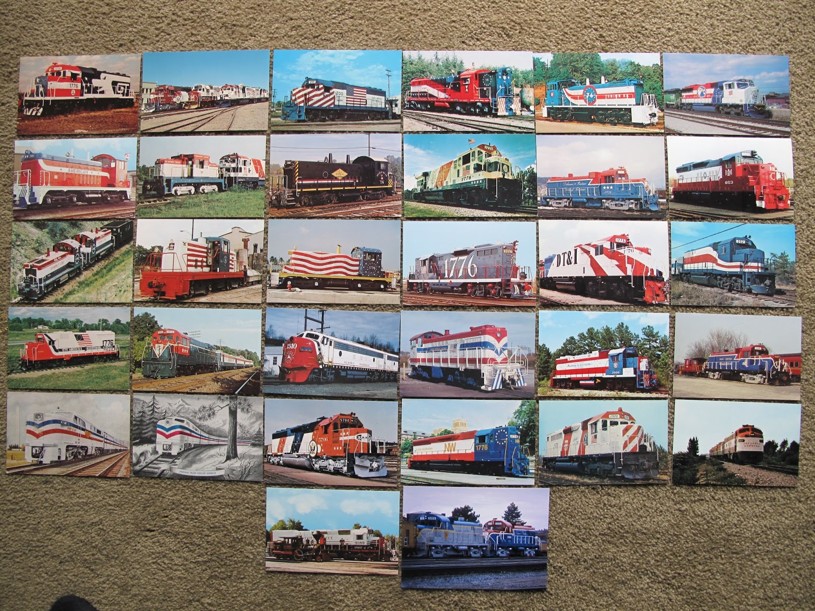
In honor of the 4th of July, I have laid out all of the post cards in my collection that celebrate the bicentennial that happened way back in 1976. There are 32 post cards that show how the various railway lines and private companies celebrated the bicentennial. None of these cards have been sent through the post office.

I see that the image overflows onto my side bars. But, I don't know how to correct that.

The oldest two are actually not celebrating the bicentennial. They are from 1948 and they are showing what is called the Freedom Train. The copyright is from 1948 by The American Heritage Foundation.

I would like to point out the train in the far right column, last row. It is the "Preamble Express". It preceded the actual 1976 Freedom Train on the tracks in order to check the security on the tracks. I would hate to be a passenger on that train if I knew what its purpose was.

Anyway.... Happy Fourth of July.